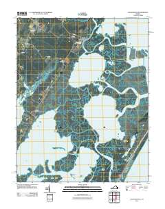
2011 Map of Wachapreague
USGS Topo · Published 2011About this map
Wachapreague serves as a central hub for the intricate marshlands and coastal waterways of Accomack County, where the Wachapreague Post Office anchors a community deeply tied to the Atlantic. The landscape is defined by long, narrow points of land such as Bradford Neck and Upshur Neck that reach into a complex system of lagoons, including Bradford Bay and Swash Bay. Inland, the agricultural and residential patterns are marked by small settlements like Locust Mount, Grangeville, and Old Trower. Beyond the mainland, the barrier islands of Parramore Island and Revel Island protect the inner coves and channels, including the deep Sloop Channel. This 2011 survey documents the fragile geography of the Eastern Shore, illustrating how the coastal roads terminate at the water’s edge in places like Quinby.
Find a feature on this map
36 named features on this map. Tap any name to fly to it.
Don’t see what you’re looking for? This feature index may not catch every label — zoom into the map to look around manually.
Map Details
Editions of this 2011 Wachapreague Map
This is the sole edition of this map. No revisions or reprints were ever made.
Other maps of this area

1931 · Accomac
USGS Topo · 1:48,000

1935 · Accomac
USGS Topo · 1:62,500

1941 · Broadwater
USGS Topo · 1:62,500

1942 · Little Machipongo Inlet
USGS Topo · 1:24,000

1942 · Nassawadox
USGS Topo · 1:24,000

1943 · Nassawadox
USGS Topo · 1:31,680

1943 · Pungoteague
USGS Topo · 1:31,680

1943 · Exmore
USGS Topo · 1:24,000

1944 · Exmore
USGS Topo · 1:31,680

1946 · Eastville
USGS Topo · 1:250,000