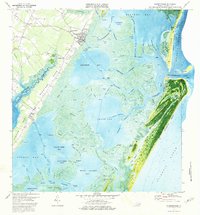
1974 Map of Wachapreague
USGS Topo · Published 1976About this map
Wachapreague and its intricate salt marsh surroundings are captured in this mid-1970s orthophotomap, which uses aerial photography to detail the complex tidal geography of the Virginia Eastern Shore. The settlement of Quinby sits at the southern edge of Bradford Neck, overlooking the expansive waters of Machipongo River. Offshore, the barrier islands of Cedar Island and Parramore Island shield the mainland from the Atlantic Ocean, creating a network of interior channels like Bradford Channel and Wachapreague Channel. Evidence of maritime safety and navigation is prominent, including a Coast Guard Station and a Lookout Tower near the Wachapreague Inlet. Inland, the landscape is dotted with small rural communities and local landmarks such as Herbert Ch and the settlements of Locust Mount and Grangeville.
Find a feature on this map
111 named features on this map. Tap any name to fly to it.
Don’t see what you’re looking for? This feature index may not catch every label — zoom into the map to look around manually.
Map Details
Editions of this 1974 Wachapreague Map
This is the sole edition of this map. No revisions or reprints were ever made.
Other maps of this area

1931 · Accomac
USGS Topo · 1:48,000

1935 · Accomac
USGS Topo · 1:62,500

1941 · Broadwater
USGS Topo · 1:62,500

1942 · Little Machipongo Inlet
USGS Topo · 1:24,000

1942 · Nassawadox
USGS Topo · 1:24,000

1943 · Nassawadox
USGS Topo · 1:31,680

1943 · Pungoteague
USGS Topo · 1:31,680

1943 · Exmore
USGS Topo · 1:24,000

1944 · Exmore
USGS Topo · 1:31,680

1946 · Eastville
USGS Topo · 1:250,000