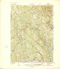
1939 Map of Wachusett Mtn
USGS Topo · Published 1939About this map
Wachusett Mountain State Reservation anchors this late 1930s landscape, providing a detailed view of the terrain before mid-century development. The Boston and Maine Railroad cuts through the region, serving critical stops at Hubbardston Sta, Princeton Sta, and Rutland Sta. This era is particularly defined by the presence of large-scale public health and infrastructure projects, notably the State Sanitorium and the Central New England Sanitorium near Rutland. A hidden but vital piece of regional engineering, the Quabbin Aqueduct, is marked with specific access points at Shaft 5 and Shaft 6, tracing its path beneath the hills. The map captures a transition where traditional village life at Princeton and North Rutland exists alongside these modernizing industrial and health facilities, all set against the numerous water bodies like Asnacomet Pond and the Ware River.
Find a feature on this map
58 named features on this map. Tap any name to fly to it.
Don’t see what you’re looking for? This feature index may not catch every label — zoom into the map to look around manually.
Map Details
Editions of this 1939 Wachusett Mtn Map
This is the sole edition of this map. No revisions or reprints were ever made.
Other maps of this area

1885 · Worcester
USGS Topo · 1:62,500

1886 · Worcester
USGS Topo · 1:62,500

1887 · Winchendon
USGS Topo · 1:62,500

1887 · Barre
USGS Topo · 1:62,500

1887 · Fitchburg
USGS Topo · 1:62,500

1889 · Fitchburg
USGS Topo · 1:62,500

1889 · Barre
USGS Topo · 1:62,500

1890 · Winchendon
USGS Topo · 1:62,500

1892 · Worcester
USGS Topo · 1:62,500

1893 · Fitchburg
USGS Topo · 1:62,500