1942 Map of Wachusett Mtn
USGS Topo · Published 1942About this map
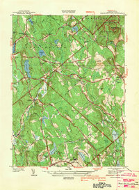
Wachusett Mountain dominates the northeast corner of this central Massachusetts landscape, surrounded by the protected grounds of the Wachusett Mtn State Reservation. Surveyed shortly before the United States entered World War II, the map illustrates an era when rural connectivity was defined by the Boston and Maine Railroad, which served local depots like Hubbardston Sta, Princeton Sta, and Rutland Sta.
Find a feature on this map
64 named features on this map. Tap any name to fly to it.
Don’t see what you’re looking for? This feature index may not catch every label — zoom into the map to look around manually.
Map Details
Editions of this 1942 Wachusett Mtn Map
2 editions found

Other maps of this area

1885 · Worcester
USGS Topo · 1:62,500

1886 · Worcester
USGS Topo · 1:62,500

1887 · Winchendon
USGS Topo · 1:62,500

1887 · Barre
USGS Topo · 1:62,500

1887 · Fitchburg
USGS Topo · 1:62,500

1889 · Fitchburg
USGS Topo · 1:62,500

1889 · Barre
USGS Topo · 1:62,500

1890 · Winchendon
USGS Topo · 1:62,500

1892 · Worcester
USGS Topo · 1:62,500

1893 · Fitchburg
USGS Topo · 1:62,500