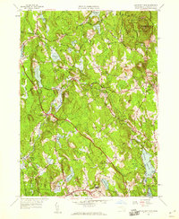
1956 Map of Wachusett Mtn
USGS Topo · Published 1959About this map
Wachusett Mountain dominates the northeastern corner of this mid-century landscape, anchoring the Wachusett Mtn State Reservation. The map captures a transition in public health and infrastructure, notably featuring the Central New England Sanatorium and Rutland State Sanatorium near the southern border in Rutland. This area was a critical node for water and transport, evidenced by the subterranean Quabbin Aqueduct passing through Hubbardston and the active presence of the Boston and Maine Railroad serving depots at Hubbardston Sta and Princeton Sta. Numerous reservoirs and ponds, including Mare Meadow Reservoir and Asnacomet Pond, highlight the region's importance to the regional water supply. Small settlements like North Rutland and Brooks are depicted alongside several family and community burial grounds, such as Woodlawn Cem and Rural Glen Cem, providing essential details for genealogists.
Find a feature on this map
66 named features on this map. Tap any name to fly to it.
Don’t see what you’re looking for? This feature index may not catch every label — zoom into the map to look around manually.
Map Details
Editions of this 1956 Wachusett Mtn Map
2 editions found
Other maps of this area

1885 · Worcester
USGS Topo · 1:62,500

1886 · Worcester
USGS Topo · 1:62,500

1887 · Winchendon
USGS Topo · 1:62,500

1887 · Barre
USGS Topo · 1:62,500

1887 · Fitchburg
USGS Topo · 1:62,500

1889 · Fitchburg
USGS Topo · 1:62,500

1889 · Barre
USGS Topo · 1:62,500

1890 · Winchendon
USGS Topo · 1:62,500

1892 · Worcester
USGS Topo · 1:62,500

1893 · Fitchburg
USGS Topo · 1:62,500