
1972 Map of Wachusett Mtn
USGS Topo · Published 1978About this map
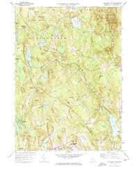
Wachusett Mtn and its surrounding state reservation dominate the eastern portion of this central Massachusetts landscape, overlooking a complex network of reservoirs and watercourses. The 1970s terrain is defined by its water management infrastructure, most notably the subterranean Quabbin Aqueduct and the Quinapoxet Reservoir, which support regional utility needs. Small settlements like Princeton and Hubbardston Station are linked by the Boston and Maine Railroad, while the educational presence of Becker Jr College sits near the southern edge of the quadrangle.
Find a feature on this map
68 named features on this map. Tap any name to fly to it.
Don’t see what you’re looking for? This feature index may not catch every label — zoom into the map to look around manually.
Map Details
Editions of this 1972 Wachusett Mtn Map
2 editions found
Other maps of this area

1885 · Worcester
USGS Topo · 1:62,500

1886 · Worcester
USGS Topo · 1:62,500

1887 · Winchendon
USGS Topo · 1:62,500

1887 · Barre
USGS Topo · 1:62,500

1887 · Fitchburg
USGS Topo · 1:62,500

1889 · Fitchburg
USGS Topo · 1:62,500

1889 · Barre
USGS Topo · 1:62,500

1890 · Winchendon
USGS Topo · 1:62,500

1892 · Worcester
USGS Topo · 1:62,500

1893 · Fitchburg
USGS Topo · 1:62,500