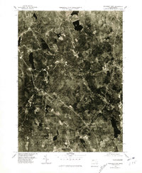
1975 Map of Wachusett Mtn.
USGS Topo · Published 1981About this map
Wachusett Mtn anchors the northern landscape of this mid-1970s orthophotograph, providing a high-contrast view of the forest and clearing patterns across central Massachusetts. The settlement of Princeton is visible to the east of the peak, while the village of North Rutland and the town of Rutland establish the southern development patterns. This aerial-based survey documents the region's complex water network, including the Ware River and the significant basin of the Quinapoxet Reservoir which feeds into the Quinapoxet River. The imagery reveals a transition from dense woodland to established town centers and rural homesteads, reflecting the post-war suburbanization and land-use changes of Worcester County. Detail seekers can observe the road alignments connecting the smaller locality of Muschopause to larger centers, as they existed in 1975.
Find a feature on this map
8 named features on this map. Tap any name to fly to it.
Don’t see what you’re looking for? This feature index may not catch every label — zoom into the map to look around manually.
Map Details
Editions of this 1975 Wachusett Mtn. Map
This is the sole edition of this map. No revisions or reprints were ever made.
Other maps of this area

1885 · Worcester
USGS Topo · 1:62,500

1886 · Worcester
USGS Topo · 1:62,500

1887 · Winchendon
USGS Topo · 1:62,500

1887 · Barre
USGS Topo · 1:62,500

1887 · Fitchburg
USGS Topo · 1:62,500

1889 · Fitchburg
USGS Topo · 1:62,500

1889 · Barre
USGS Topo · 1:62,500

1890 · Winchendon
USGS Topo · 1:62,500

1892 · Worcester
USGS Topo · 1:62,500

1893 · Fitchburg
USGS Topo · 1:62,500