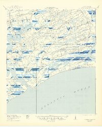
1919 Map of Wadmalaw Island
USGS Topo · Published 1944About this map
Wadmalaw Island and its neighboring sea islands are documented here during a period defined by tidal agriculture and rural community life before mid-century modernization. The coastal landscape is punctuated by numerous small institutions such as Jerusalem School, Bogle School, and Stono School, reflecting the era's localized educational structure. In the north, the Seaboard Air Line railway connects Meggett to the mainland, while the southern reaches near Bohicket Creek show established settlements like Rockville and the Kiawato Club. Historical industrial and defensive traces appear through the Crate Mill on Johns Island and the Old Fort on Horse Island. The complex drainage of Leadenwah Creek and Kiawah River illustrates the intricate shoreline of Kiawah Island and Seabrook Island long before their transition into modern resort communities.
Find a feature on this map
72 named features on this map. Tap any name to fly to it.
Don’t see what you’re looking for? This feature index may not catch every label — zoom into the map to look around manually.
Map Details
Editions of this 1919 Wadmalaw Island Map
2 editions found
Other maps of this area
1918 · Kiawah Island
USGS Topo · 1:21,120

1918 · Cottageville
USGS Topo · 1:62,500

1919 · Johns Island
USGS Topo · 1:21,120
1919 · Edisto Island
USGS Topo · 1:62,500

1919 · Wadmelaw Island
USGS Topo · 1:62,500

1919 · Charleston
USGS Topo · 1:21,120

1919 · James Island
USGS Topo · 1:21,120

1919 · Legareville
USGS Topo · 1:21,120

1920 · St. Helena Sound
USGS Topo · 1:62,500

1920 · Ravenels
USGS Topo · 1:62,500