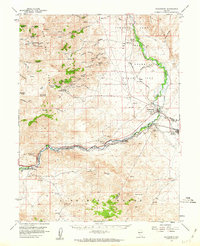
1957 Map of Wadsworth
USGS Topo · Published 1963About this map
Wadsworth serves as the central hub of this mid-century landscape, where the Southern Pacific railroad meets the winding course of the Truckee River. The map documents a critical juncture for regional water management, featuring the Derby Dam and the start of the Truckee Canal, which diverts water toward Fernley. This infrastructure, combined with the presence of the Pyramid Lake Indian Reservation, illustrates the complex irrigation and land-use patterns essential to the high desert economy during the 1950s.
Find a feature on this map
62 named features on this map. Tap any name to fly to it.
Don’t see what you’re looking for? This feature index may not catch every label — zoom into the map to look around manually.
Map Details
Editions of this 1957 Wadsworth Map
3 editions found

Other maps of this area

1890 · Wadsworth
USGS Topo · 1:125,000

1891 · Carson
USGS Topo · 1:125,000

1891 · Wabuska
USGS Topo · 1:125,000

1891 · Reno
USGS Topo · 1:125,000

1892 · Wadsworth
USGS Topo · 1:125,000

1893 · Carson
USGS Topo · 1:125,000

1893 · Reno
USGS Topo · 1:125,000

1894 · Wadsworth
USGS Topo · 1:125,000

1894 · Wabuska
USGS Topo · 1:125,000

1950 · Virginia City
USGS Topo · 1:62,500