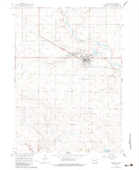
1964 Map of Wagner
USGS Topo · Published 1983About this map
Wagner serves as the primary hub of this Charles Mix County landscape, situated along the Chicago Milwaukee St Paul and Pacific railroad line. The map illustrates a meticulously planned rural grid system, punctuated by a series of numbered country schoolhouses such as School No 4 and School No 51, which reflect the early-to-mid-20th-century educational structure of South Dakota. The topography is defined by the winding course of Choteau Creek and the notable Old Indian Treaty Boundary that slices diagonally through the southeast, marking a significant historical jurisdictional line.
Find a feature on this map
22 named features on this map. Tap any name to fly to it.
Don’t see what you’re looking for? This feature index may not catch every label — zoom into the map to look around manually.
Map Details
Editions of this 1964 Wagner Map
2 editions found
Other maps of this area

1955 · Mitchell
USGS Topo · 1:250,000

1955 · O'Neill
USGS Topo · 1:250,000

1959 · O'Neill
USGS Topo · 1:250,000

1959 · Mitchell
USGS Topo · 1:250,000

1964 · Wagner NE
USGS Topo · 1:24,000

1964 · Ravinia
USGS Topo · 1:24,000

1964 · Wagner
USGS Topo · 1:24,000

1964 · Lynch NE
USGS Topo · 1:24,000

1964 · Wagner SW
USGS Topo · 1:24,000
1964 · Marty
USGS Topo · 1:24,000