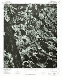
1976 Map of Wagram
USGS Topo · Published 1978About this map
Agricultural patterns and woodland tracts define the landscape of Scotland County in the mid-1970s, as seen in this aerial-based study produced by the U.S. Geological Survey and the Soil Conservation Service. The map centers on the small rail-aligned settlement of Bowmore, situated amidst a patchwork of large fields and dark timber stands. To the southwest, the town of Wagram serves as a primary hub for this rural community, connected to the nearby cluster at Hickory Grove. The imagery reveals the distinct textures of the North Carolina Coastal Plain, where drainage patterns and field boundaries reflect generations of land use. This orthophotoquad provides researchers with a precise visual record of property lines and rural infrastructure before the expansion of modern development transformed the regional footprint.
Find a feature on this map
3 named features on this map. Tap any name to fly to it.
Don’t see what you’re looking for? This feature index may not catch every label — zoom into the map to look around manually.
Map Details
Editions of this 1976 Wagram Map
This is the sole edition of this map. No revisions or reprints were ever made.
Other maps of this area

1948 · Southern Pines
USGS Topo · 1:62,500

1948 · Clifdale
USGS Topo · 1:62,500

1948 · Pinebluff
USGS Topo · 1:24,000

1948 · Nicholson Creek
USGS Topo · 1:24,000

1948 · Mc Cain
USGS Topo · 1:24,000

1949 · Wagram
USGS Topo · 1:24,000

1949 · Laurinburg
USGS Topo · 1:24,000

1949 · Silver Hill
USGS Topo · 1:24,000

1949 · Wakulla
USGS Topo · 1:24,000

1949 · Laurinburg
USGS Topo · 1:62,500