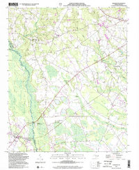
2002 Map of Wagram
USGS Topo · Published 2002About this map
The Lumber River snakes through the swampy lowlands along the Hoke and Scotland County border, defining the western edge of a landscape shaped by rural industry and agriculture. This 2002 update, based on mid-century topography and imagery from the early 1980s, reveals a persistent network of small rural settlements like Bowmore, Edinburg, and Wagram. The Laurinburg and Southern RR cuts a straight path southeast toward the Sandhills State Game Land, illustrating the historical importance of rail transport in the timber and farming economy of the Carolina coastal plain.
Find a feature on this map
33 named features on this map. Tap any name to fly to it.
Don’t see what you’re looking for? This feature index may not catch every label — zoom into the map to look around manually.
Map Details
Editions of this 2002 Wagram Map
This is the sole edition of this map. No revisions or reprints were ever made.
Other maps of this area

1948 · Southern Pines
USGS Topo · 1:62,500

1948 · Clifdale
USGS Topo · 1:62,500

1948 · Pinebluff
USGS Topo · 1:24,000

1948 · Nicholson Creek
USGS Topo · 1:24,000

1948 · Mc Cain
USGS Topo · 1:24,000

1949 · Wagram
USGS Topo · 1:24,000

1949 · Laurinburg
USGS Topo · 1:24,000

1949 · Silver Hill
USGS Topo · 1:24,000

1949 · Wakulla
USGS Topo · 1:24,000

1949 · Laurinburg
USGS Topo · 1:62,500