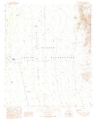
1990 Map of Wahak Hotrontk
USGS Topo · Published 1990About this map
The Papago Indian Reservation encompasses the arid reaches of the Quijotoa Valley in this 1990 provisional study. The landscape is defined by the sharp transition from the valley floor to the high ridges of the Sierra Blanca in the northeast. Water management is central to the settlement pattern here, as evidenced by a complex network of Check Dams and isolated water sources like Tracys Well and San Simon Well. The map documents the presence of established communities such as Wahak Hotrontk and Komak Wuacho, alongside archeological footprints at Stotonyak (Site) and Ahan Owuch (Site). These sites, connected by 4WD trails, reflect a long-standing human adaptation to the desert environment, where even a small Prospect in the mountains or a solitary Water Tank represents a vital point of interest.
Find a feature on this map
18 named features on this map. Tap any name to fly to it.
Don’t see what you’re looking for? This feature index may not catch every label — zoom into the map to look around manually.
Map Details
Editions of this 1990 Wahak Hotrontk Map
This is the sole edition of this map. No revisions or reprints were ever made.
Other maps of this area

1953 · Ajo
USGS Topo · 1:250,000

1957 · Ajo
USGS Topo · 1:250,000

1958 · Ajo
USGS Topo · 1:250,000

1962 · Ajo
USGS Topo · 1:250,000

1963 · Ajo
USGS Topo · 1:250,000

1963 · Gu Achi
USGS Topo · 1:62,500

1963 · Quijotoa Mts
USGS Topo · 1:62,500

1963 · Cimarron Peak
USGS Topo · 1:62,500

1963 · Pisinimo
USGS Topo · 1:62,500

1967 · Ajo
USGS Topo · 1:250,000
Featured Places
- Komak Wuacho, Pisinemo District
- Ahan Owuch, Pisinemo District
- Stotonyak, Pisinemo District
- Wahak Hotrontk, Pisinemo District
- Pisinemo District, AZ