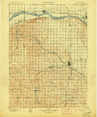
1899 Map of Wahoo
USGS Topo · Published 1914About this map
Platte River dynamics and a complex web of late-nineteenth-century rail lines define this portion of eastern Nebraska. The northern border follows the river's braided course past North Bend and Ames, while the interior landscape is etched by the Chicago And North Western Line and multiple branches of the Union Pacific Railroad. This 1890s survey by Jno. H. Renshawe documents a period of intense agricultural settlement, organized into distinct townships such as Bohemia, Skull Creek, and Mariposa. These divisions reflect the ethnic enclaves of the era, centered around growing hubs like Wahoo and Valparaiso. Genealogists will find interest in the precise placement of smaller stations and rural post offices including Swedeburg, Touhy, and Plasi, many of which served as vital collection points for the region's grain economy before the modern consolidation of transport networks.
Find a feature on this map
70 named features on this map. Tap any name to fly to it.
Don’t see what you’re looking for? This feature index may not catch every label — zoom into the map to look around manually.
Map Details
Editions of this 1899 Wahoo Map
3 editions found
Other maps of this area

1893 · Fremont
USGS Topo · 1:125,000

1896 · Fremont
USGS Topo · 1:125,000

1897 · Lincoln
USGS Topo · 1:125,000

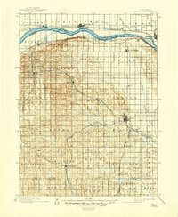
1899 · Wahoo
USGS Topo · 1:125,000

1899 · David City
USGS Topo · 1:125,000

1903 · Weeping Water
USGS Topo · 1:125,000

1929 · Weeping Water
USGS Topo · 1:125,000

1934 · Seward
USGS Topo · 1:48,000

1939 · Seward
USGS Topo · 1:62,500

1955 · Fremont
USGS Topo · 1:250,000