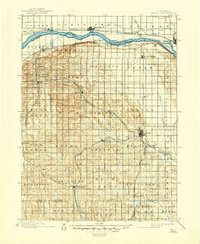
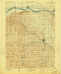
1899 Map of Wahoo
USGS Topo · Published 1946About this map
The Platte River defines the northern reaches of this late 19th-century landscape, where early railroad expansion dictated the growth of Saunders County. This 1899 survey, based on reconnaissance from the mid-1890s, reveals a dense network of early branch lines including the Omaha and Republican Valley Line and the Schuyler and Western Line, which connected agricultural hubs like Wahoo and Valparaiso to the wider region. Beyond the rail corridors, the terrain is divided into namesake townships such as Bohemia and Mariposa, reflecting the diverse European immigrant heritage that settled the rolling prairie. Smaller rail-stop communities like Prague, Malmo, and Weston appear at their peak of early development, before the shifts in 20th-century transportation changed the rural economy. Waterways like Cottonwood Creek and Silver Creek lace through the townships, illustrating the natural drainage patterns that influenced farmstead placement.
Find a feature on this map
68 named features on this map. Tap any name to fly to it.
Don’t see what you’re looking for? This feature index may not catch every label — zoom into the map to look around manually.
Map Details
Editions of this 1899 Wahoo Map
3 editions found

Historical Maps of Fremont Through Time
1 maps found