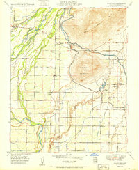
1950 Map of Wahtoke
USGS Topo · Published 1950About this map
The Kings River dictates the landscape of this Central Valley region, with the rugged elevations of Campbell Mountain and Jesse Morrow Mtn rising sharply above the irrigated agricultural floor. This 1950 edition documents an intricate network of water management, including the Alta Main Canal, Byrd Slough, and numerous ditches that fueled the local economy. Small rural settlements like Centerville and Minkler serve as community hubs, while the Atchison Topeka and Santa Fe railroad provides the vital transit link for goods. Local history is well-preserved through labels for the Acres Cem, the Great Western Airport, and multiple rural schoolhouses such as Frankwood School and Great Western School. The presence of the KSGN Radio Sta and a local Winery reflects the mid-century development of Fresno County's rural infrastructure and industry.
Find a feature on this map
54 named features on this map. Tap any name to fly to it.
Don’t see what you’re looking for? This feature index may not catch every label — zoom into the map to look around manually.
Map Details
Editions of this 1950 Wahtoke Map
2 editions found
Other maps of this area

1920 · Orangedale School
USGS Topo · 1:24,000

1921 · Squaw Valley
USGS Topo · 1:31,680

1922 · Round Mountain
USGS Topo · 1:31,680

1922 · Trimmer
USGS Topo · 1:96,000

1923 · Sultana
USGS Topo · 1:31,680

1923 · Orangedale School
USGS Topo · 1:31,680

1923 · Wahtoke
USGS Topo · 1:31,680

1923 · Sanger
USGS Topo · 1:31,680

1924 · Reedley
USGS Topo · 1:31,680

1924 · Selma
USGS Topo · 1:31,680