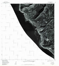
1977 Map of Waianae
USGS Topo · Published 1984About this map
Waianae and its neighboring leeward coast settlements are captured in high-detail orthophotography during the late 1970s. This survey, produced by the Geological Survey in cooperation with the State of Hawaii, provides a rare overhead perspective of the residential and agricultural patterns along the coast before subsequent decades of development. The imagery clearly shows the transition from the sandy shores of the Pacific Ocean to the steep, fluted ridges of the interior mountains. Coastal communities such as Makaha, Maili, and Nanakuli are visible as distinct clusters of development, revealing the extent of local infrastructure and land use at the time the aerial photographs were taken in late 1977. This document is particularly valuable for observing the density of housing and the specific layout of roads and fields along this stretch of Oahu's western shore.
Find a feature on this map
5 named features on this map. Tap any name to fly to it.
Don’t see what you’re looking for? This feature index may not catch every label — zoom into the map to look around manually.
Map Details
Editions of this 1977 Waianae Map
This is the sole edition of this map. No revisions or reprints were ever made.
Other maps of this area

1953 · Haleiwa
USGS Topo · 1:24,000

1953 · Schofield Barracks
USGS Topo · 1:24,000

1953 · Ewa
USGS Topo · 1:24,000

1954 · Oahu
USGS Topo · 1:250,000

1954 · Waianae
USGS Topo · 1:24,000

1954 · Kaena
USGS Topo · 1:24,000

1960 · Haleiwa
USGS Topo · 1:24,000

1960 · Schofield Barracks
USGS Topo · 1:24,000

1961 · Oahu
USGS Topo · 1:250,000
1962 · Ewa
USGS Topo · 1:24,000