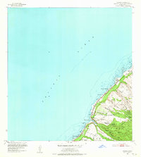
1952 Map of Waimea
USGS Topo · Published 1965About this map
The North Shore of Oahu is defined by its dramatic transition from the Pacific Ocean to the steep gulches and ridges of the Pupukea Forest Reserve. Coastal life centers on the sweep of Waimea Bay and the legendary sands of Sunset Beach, connected by the Kamerameha Highway. This mid-century survey captures the region's deep cultural history through the preservation of ancient sites like Puu O Mahuka Heiau overlooking the bay and Kupupolo Heiau further south along Kawailoa Beach. Inland, the landscape is a network of water-carved valleys, including Hakuola Gulch and Paumalu Gulch, where several streams converge. The mapped area reflects a mix of small settlements at Maunawai and Waimea alongside agricultural and institutional presence at Pupukea Homestead and Camp Pupukea, all situated within the jurisdictional bounds of the KoolauLoa District and Waialua District.
Find a feature on this map
41 named features on this map. Tap any name to fly to it.
Don’t see what you’re looking for? This feature index may not catch every label — zoom into the map to look around manually.
Map Details
Editions of this 1952 Waimea Map
2 editions found
Other maps of this area

1952 · Waimea
USGS Topo · 1:24,000

1953 · Haleiwa
USGS Topo · 1:24,000

1953 · Hauula
USGS Topo · 1:24,000

1954 · Oahu
USGS Topo · 1:250,000

1954 · Kahuku
USGS Topo · 1:24,000

1954 · Kaena
USGS Topo · 1:24,000

1960 · Haleiwa
USGS Topo · 1:24,000

1961 · Oahu
USGS Topo · 1:250,000
1964 · Kaena
USGS Topo · 1:24,000

1965 · Oahu
USGS Topo · 1:250,000