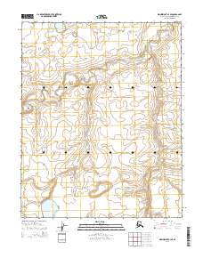
2014 Map of Wainwright A-3 SE
USGS Topo · Published 2014About this map
The Ivisaruk River meanders across this Arctic landscape in the North Slope Borough, carving a complex series of tight oxbows and abandoned channels through the tundra. The water-rich terrain of this 2014 survey is defined by the Natvakrak Lakes in the southwestern quadrant, illustrating the vast, unpopulated drainage systems characteristic of the region. The landscape is mapped according to the Public Land Survey System, showing the intersections of Townships 8 and 9 North across Ranges 33 and 34 West. This remote coastal plain environment remains largely untouched by permanent human settlement or industrial infrastructure, with the hydrological patterns of the river and lakes serving as the primary landmarks for navigation and land management in this portion of Alaska.
Find a feature on this map
6 named features on this map. Tap any name to fly to it.
Don’t see what you’re looking for? This feature index may not catch every label — zoom into the map to look around manually.
Map Details
Editions of this 2014 Wainwright A-3 SE Map
This is the sole edition of this map. No revisions or reprints were ever made.
Other maps of this area

1951 · Utukok River
USGS Topo · 1:250,000

1951 · Wainwright
USGS Topo · 1:250,000

1955 · Wainwright
USGS Topo · 1:250,000

1955 · Wainwright A-2
USGS Topo · 1:63,360
1955 · Utukok River D-3
USGS Topo · 1:63,360
1955 · Wainwright A-3
USGS Topo · 1:63,360

1956 · Utukok River
USGS Topo · 1:250,000

1964 · Wainwright
USGS Topo · 1:250,000

1965 · Utukok River
USGS Topo · 1:250,000
1984 · Utukok River D-2
USGS Topo · 1:63,360