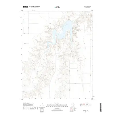
2019 Map of Waka SW
USGS Topo · Published 2019About this map
Palo Duro Lake dominates the upper reaches of this northern Texas landscape, its branching fingers reaching into the surrounding drainages of the High Plains. This 2019 survey of Hansford County illustrates a region defined by extensive drainage systems and agricultural access, where the intricate network of local roads such as CO RD J and CO RD 24 facilitate movement across the plateau. The terrain is marked by the distinct transition from flat upland fields to the carved ravines that feed into the central reservoir, reflecting the modern management of water resources in this part of the Panhandle. While the map is sparse on named settlements, the density of rural road identifiers and the expansive water feature provide a detailed record of contemporary land use and topographic character in the Waka SW area.
Find a feature on this map
1 named feature on this map. Tap any name to fly to it.
Don’t see what you’re looking for? This feature index may not catch every label — zoom into the map to look around manually.
Map Details
Editions of this 2019 Waka SW Map
This is the sole edition of this map. No revisions or reprints were ever made.
Other maps of this area

1954 · Perryton
USGS Topo · 1:250,000

1958 · Perryton
USGS Topo · 1:250,000

1962 · Kimball
USGS Topo · 1:24,000

1962 · Hansford Camp
USGS Topo · 1:24,000

1962 · Hansford
USGS Topo · 1:24,000

1962 · Waka SW
USGS Topo · 1:24,000

1962 · Spearman
USGS Topo · 1:24,000

1973 · Horseshoe Hill
USGS Topo · 1:24,000

1973 · Waka
USGS Topo · 1:24,000

1973 · Spearman NE
USGS Topo · 1:24,000