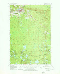
1955 Map of Wakefield
USGS Topo · Published 1976About this map
Wakefield serves as the industrial and social anchor of this Upper Peninsula landscape, situated alongside the expansive waters of Sunday Lake. In the mid-1950s, the region's mining heritage is clearly visible through the numerous Gravel Pits and substantial Mine Dumps concentrated near the Chicago mine and the settlement of Ramsay. This industrial footprint is balanced by the massive tracts of the Ottawa National Forest, which dominate the central and southern portions of the map. The rugged terrain is punctuated by significant heights like Wolf Mountain and the Verona Lookout Tower. To the south, the landscape transitions into a dense network of glacial lakes including Chaney Lake and Mishike Lake along the Michigan-Wisconsin border. The Chicago and North Western railroad provides the primary transit corridor, linking the iron-rich settlements of Verona, Plymouth, and Ramsay.
Find a feature on this map
114 named features on this map. Tap any name to fly to it.
Don’t see what you’re looking for? This feature index may not catch every label — zoom into the map to look around manually.
Map Details
Editions of this 1955 Wakefield Map
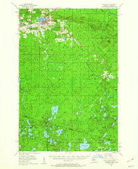
3 editions found

Other maps of this area

1939 · Trout Lake
USGS Topo · 1:48,000

1939 · Winchester
USGS Topo · 1:48,000

1940 · Mercer
USGS Topo · 1:48,000

1943 · Ironwood
USGS Topo · 1:48,000

1945 · Mercer
USGS Topo · 1:48,000

1946 · Winchester
USGS Topo · 1:48,000

1946 · Trout Lake
USGS Topo · 1:48,000

1947 · Mercer
USGS Topo · 1:48,000

1949 · Trout Lake
USGS Topo · 1:48,000

1953 · Ashland
USGS Topo · 1:250,000