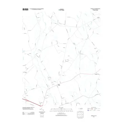
2013 Map of Wakulla
USGS Topo · Published 2013About this map
Floral College and the surrounding Robeson County landscape are defined by a network of expansive wetlands and winding watercourses. The Lumber River meanders through the western portion of the area, joined by Shoe Heel Cr and the quiet waters of Lees Mill Pond. The terrain is deeply influenced by drainage patterns, with significant features like Gum Swamp, Jordan Swamp, and Long Swamp carving through the coastal plain. In the northwest, the Laurinburg-Maxton Airport stands as a prominent modern landmark near the unincorporated community of Duffies and the namesake settlement of Wakulla. A complex grid of rural roads, including several routes like Old Wire Rd and Old Maxton Rd, connects these scattered settlements and reflects the long-standing agricultural and transportation corridors of the region.
Find a feature on this map
119 named features on this map. Tap any name to fly to it.
Don’t see what you’re looking for? This feature index may not catch every label — zoom into the map to look around manually.
Map Details
Editions of this 2013 Wakulla Map
This is the sole edition of this map. No revisions or reprints were ever made.
Other maps of this area

1949 · Wagram
USGS Topo · 1:24,000

1949 · Laurinburg
USGS Topo · 1:24,000

1949 · Silver Hill
USGS Topo · 1:24,000

1949 · Wakulla
USGS Topo · 1:24,000

1949 · Laurinburg
USGS Topo · 1:62,500

1953 · Florence
USGS Topo · 1:250,000

1954 · Florence
USGS Topo · 1:250,000

1957 · Laurinburg
USGS Topo · 1:24,000

1971 · Johns
USGS Topo · 1:24,000
1972 · Raeford
USGS Topo · 1:24,000