
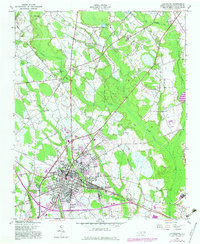
1957 Map of Laurinburg
USGS Topo · Published 1960About this map
Laurinburg serves as the industrial and transport hub of Scotland County in the late 1950s, defined by the convergence of the Southern and Laurinburg And Southern railroads. The town's growth is reflected in residential developments like Middleton Heights, Lincoln Heights, and North View, while East Laurinburg stands distinct to the east. Local industry is anchored by the Gibson Mill and specialized infrastructure such as the Filtration Plant and the Radio Tower (WEWO).
Find a feature on this map
46 named features on this map. Tap any name to fly to it.
Don’t see what you’re looking for? This feature index may not catch every label — zoom into the map to look around manually.
Map Details
Editions of this 1957 Laurinburg Map
2 editions found
Other maps of this area

1942 · Rockingham
USGS Topo · 1:125,000

1949 · Gibson
USGS Topo · 1:24,000

1949 · Wagram
USGS Topo · 1:24,000

1949 · Laurinburg
USGS Topo · 1:24,000

1949 · Silver Hill
USGS Topo · 1:24,000

1949 · Marston
USGS Topo · 1:24,000

1949 · Wakulla
USGS Topo · 1:24,000

1949 · Hamlet
USGS Topo · 1:62,500

1949 · Laurinburg
USGS Topo · 1:62,500

1953 · Florence
USGS Topo · 1:250,000