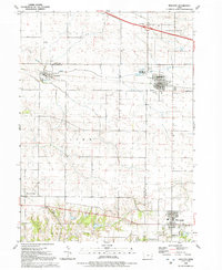
1991 Map of Walcott
USGS Topo · Published 1992About this map
Walcott and Blue Grass anchor this late-twentieth-century landscape where agricultural traditions meet growing infrastructure on the Muscatine and Scott county line. The terrain is defined by the winding course of Mud Creek and various water bodies like Lamps Pond, while the rural interior is dotted with legacy sites such as Parr Cem and Pleasant Prairie. Local aviation is represented by Workman Airfield, situated north of Stockton. In the town centers, civic life is clearly marked with Victory Pk, City Hall, and the Community Ch. The map illustrates the shift from isolated farmsteads to suburban growth, evidenced by the proximity of Interchange 284 and the modern footprints of local services like the Sewage Disposal Ponds.
Find a feature on this map
28 named features on this map. Tap any name to fly to it.
Don’t see what you’re looking for? This feature index may not catch every label — zoom into the map to look around manually.
Map Details
Editions of this 1991 Walcott Map
This is the sole edition of this map. No revisions or reprints were ever made.
Other maps of this area

1890 · Durant
USGS Topo · 1:62,500

1891 · Davenport
USGS Topo · 1:62,500

1894 · Durant
USGS Topo · 1:62,500

1894 · Davenport
USGS Topo · 1:62,500

1901 · Rock Island
USGS Topo · 1:125,000

1910 · Rock Island
USGS Topo · 1:125,000

1912 · Milan
USGS Topo · 1:62,500

1916 · Edgington
USGS Topo · 1:62,500

1938 · Edgington
USGS Topo · 1:62,500

1944 · Milan
USGS Topo · 1:62,500