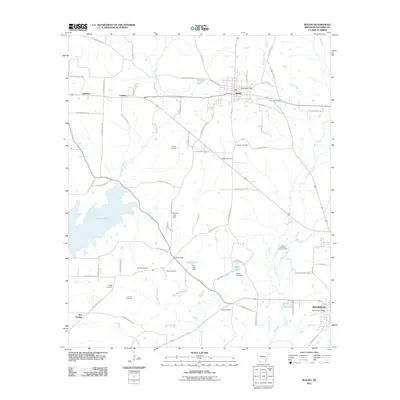
2011 Map of Waldo
USGS Topo · Published 2011About this map
Waldo serves as the primary hub of this Arkansas landscape, where the Waldo Water Tower marks the intersection of rural life and early 21st-century infrastructure. The region is characterized by a high concentration of family and community burial grounds, such as Strong Cemetery, Barlow Cemetery, and Scott Cemetery, which are scattered among the timber and oil lands of Columbia County. To the west, the expansive Lake Columbia dominates the terrain, while the Big Creek Oil and Gas Field indicates the industrial footprint of the energy sector near the Barlow Branch and Big Creek. Smaller settlements like Jefferson and Lumber appear along the road networks, connected by numerous county routes. The drainage patterns of Beech Creek and Dismukes Branch flow through the lowlands, shaping the geography between the established towns and the rises of Hurricane Ridge near the edge of Magnolia.
Find a feature on this map
78 named features on this map. Tap any name to fly to it.
Don’t see what you’re looking for? This feature index may not catch every label — zoom into the map to look around manually.
Map Details
Editions of this 2011 Waldo Map
This is the sole edition of this map. No revisions or reprints were ever made.
Other maps of this area

1953 · El Dorado
USGS Topo · 1:250,000

1957 · El Dorado
USGS Topo · 1:250,000

1958 · El Dorado
USGS Topo · 1:250,000

1960 · El Dorado
USGS Topo · 1:250,000

1960 · Bussey
USGS Topo · 1:24,000

1960 · Macedonia
USGS Topo · 1:24,000

1966 · Calhoun
USGS Topo · 1:24,000

1968 · Buckner
USGS Topo · 1:24,000

1968 · Lamartine
USGS Topo · 1:24,000
1968 · Falcon
USGS Topo · 1:24,000