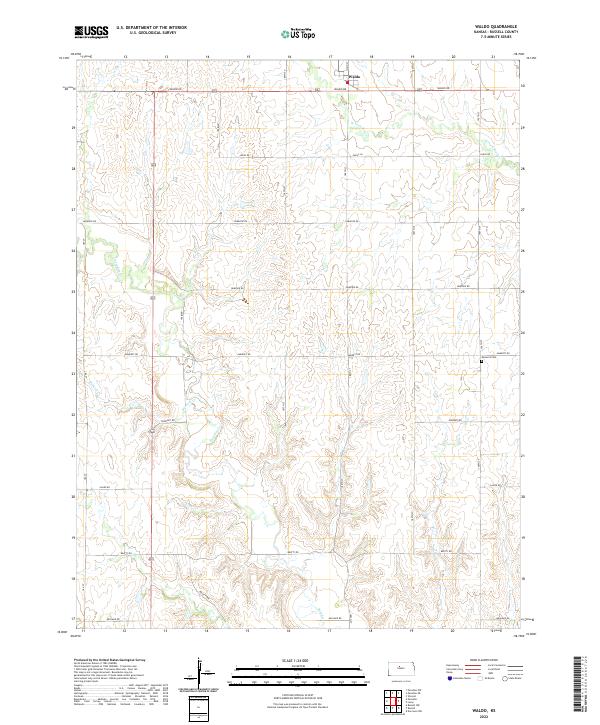
2022 Map of Waldo
USGS Topo · Published 2022About this map
Waldo stands as the primary settlement in this section of Russell County, situated along the northern edge of the survey area where Main St and Waldo Rd intersect. The surrounding landscape is defined by the headwaters and drainage of Paradise Cr and Boswell Cr, which carve through the plains. The section lines are rigorously defined by a grid of rural routes including Luray Rd and Paradise Rd, reflecting the enduring structure of the Public Land Survey System across the Kansas prairie. Genealogy researchers will find the Amherst Cem located in the eastern portion of the quadrangle near 190th St, providing a specific point of interest for local family history. The drainage of W Fork Wolf Cr further illustrates the hydrological patterns that have shaped agricultural land use and settlement placement in this region.
Find a feature on this map
27 named features on this map. Tap any name to fly to it.
Don’t see what you’re looking for? This feature index may not catch every label — zoom into the map to look around manually.
Map Details
Editions of this 2022 Waldo Map
This is the sole edition of this map. No revisions or reprints were ever made.
Other maps of this area

1896 · Osborne
USGS Topo · 1:125,000

1896 · Russell
USGS Topo · 1:125,000

1955 · Great Bend
USGS Topo · 1:250,000

1955 · Beloit
USGS Topo · 1:250,000

1957 · Great Bend
USGS Topo · 1:250,000

1958 · Great Bend
USGS Topo · 1:250,000

1959 · Beloit
USGS Topo · 1:250,000

1967 · Russell NW
USGS Topo · 1:24,000
1967 · Dorrance NW
USGS Topo · 1:24,000

1967 · Russell
USGS Topo · 1:24,000