1913 Map of Waldoboro
USGS Topo · Published 1961About this map
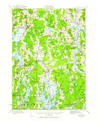
The Medomak River corridor defines this coastal Maine landscape, serving as the central artery for the thriving village of Waldoboro. This 1913 survey details a region defined by its tidal inlets and small-scale agricultural settlements, connected by the Maine Central railroad passing through Winslows Mills and Glendon Station. The map illustrates a dense network of early 20th-century rural infrastructure, featuring over twenty-five named schools including Duckpuddle School, Slaigo School, and Hodge School.
Find a feature on this map
177 named features on this map. Tap any name to fly to it.
Don’t see what you’re looking for? This feature index may not catch every label — zoom into the map to look around manually.
Map Details
Editions of this 1913 Waldoboro Map
2 editions found

Other maps of this area

1893 · Vassalboro
USGS Topo · 1:62,500

1893 · Wiscasset
USGS Topo · 1:62,500

1893 · Boothbay
USGS Topo · 1:62,500

1898 · Vassalboro
USGS Topo · 1:62,500

1904 · Monhegan
USGS Topo · 1:62,500

1904 · Tenants Harbor
USGS Topo · 1:62,500

1904 · Rockland
USGS Topo · 1:62,500

1906 · Tennant Harbor
USGS Topo · 1:62,500

1906 · Monhegan
USGS Topo · 1:62,500

1906 · Rockland
USGS Topo · 1:62,500