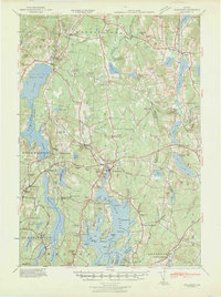
1941 Map of Waldoboro
USGS Topo · Published 1941About this map
The Medomak River valley serves as the central artery for this Midcoast Maine region, where the Maine Central RR connects coastal commerce through the village of Waldoboro. This 1941 survey, updated using aerial photography from the 97th Observation Squadron, reveals a landscape defined by its transition from inland agricultural hamlets to the complex salt-water inlets of Muscongus Bay. In the western portion, the expansive Damariscotta Lake and Pemaquid Pond dominate the terrain, surrounded by family-named landmarks like Winslow Hill and Bodge Hill.
Find a feature on this map
163 named features on this map. Tap any name to fly to it.
Don’t see what you’re looking for? This feature index may not catch every label — zoom into the map to look around manually.
Map Details
Editions of this 1941 Waldoboro Map
This is the sole edition of this map. No revisions or reprints were ever made.
Other maps of this area
1893 · Vassalboro
USGS Topo · 1:62,500
1893 · Wiscasset
USGS Topo · 1:62,500
1893 · Boothbay
USGS Topo · 1:62,500
1898 · Vassalboro
USGS Topo · 1:62,500
1904 · Monhegan
USGS Topo · 1:62,500
1904 · Tenants Harbor
USGS Topo · 1:62,500
1904 · Rockland
USGS Topo · 1:62,500
1906 · Tennant Harbor
USGS Topo · 1:62,500
1906 · Monhegan
USGS Topo · 1:62,500
1906 · Rockland
USGS Topo · 1:62,500