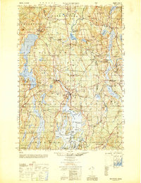
1950 Map of Waldoboro
USGS Topo · Published 1950About this map
The Medomak River valley serves as the central artery for this mid-century survey of the Maine coastal interior, where small agriculture and early industrial settlements define the landscape. The village of Waldoboro and the nearby Winslow Mills indicate a local economy tied to both the river and the rail infrastructure of the day. A dense network of small rural schoolhouses, such as Duckpuddle Sch and Manktown Sch, are scattered throughout the hills, reflecting the community structure of Lincoln and Knox Counties before the consolidation of rural districts.
Find a feature on this map
164 named features on this map. Tap any name to fly to it.
Don’t see what you’re looking for? This feature index may not catch every label — zoom into the map to look around manually.
Map Details
Editions of this 1950 Waldoboro Map
This is the sole edition of this map. No revisions or reprints were ever made.
Other maps of this area

1893 · Vassalboro
USGS Topo · 1:62,500

1893 · Wiscasset
USGS Topo · 1:62,500

1893 · Boothbay
USGS Topo · 1:62,500

1898 · Vassalboro
USGS Topo · 1:62,500

1904 · Monhegan
USGS Topo · 1:62,500

1904 · Tenants Harbor
USGS Topo · 1:62,500

1904 · Rockland
USGS Topo · 1:62,500

1906 · Tennant Harbor
USGS Topo · 1:62,500

1906 · Monhegan
USGS Topo · 1:62,500

1906 · Rockland
USGS Topo · 1:62,500