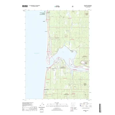
2020 Map of Waldport
USGS Topo · Published 2020About this map
Waldport stands as the central hub of this coastal survey, situated where the Alsea River meets the expansive Alsea Bay. The landscape is a mix of maritime industry and protected woodlands, with the town's residential streets and the Memorial Home Cem bordered by the Siuslaw National Forest. Along the Pacific coastline, small communities like Seal Rock, Holly Beach, and Wakonda Beach are connected by the coastal highway, serving as gateways to offshore landmarks such as Elephant Rock and the protected habitats of the Oregon Islands National Wildlife Refuge. Inland, the topography rises toward Mt Eckman and Burnt Timber Mtn, while the southern reaches of the map feature the Wakonda Beach State Airport. This layout reveals the area's reliance on both its sheltered bay for navigation and the timber-rich hillsides of the Oregon Coast Range.
Find a feature on this map
89 named features on this map. Tap any name to fly to it.
Don’t see what you’re looking for? This feature index may not catch every label — zoom into the map to look around manually.
Map Details
Editions of this 2020 Waldport Map
This is the sole edition of this map. No revisions or reprints were ever made.
Other maps of this area

1922 · Waldport
USGS Topo · 1:62,500

1942 · Waldport
USGS Topo · 1:62,500

1942 · Yaquina
USGS Topo · 1:62,500

1942 · Tidewater
USGS Topo · 1:62,500

1942 · Toledo
USGS Topo · 1:62,500

1953 · Salem
USGS Topo · 1:250,000

1954 · Salem
USGS Topo · 1:250,000

1956 · Tidewater
USGS Topo · 1:62,500

1956 · Waldport
USGS Topo · 1:62,500

1957 · Yaquina
USGS Topo · 1:62,500