
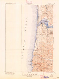
1922 Map of Waldport
USGS Topo · Published 1922About this map
Alsea Bay and its surrounding coastal settlements define this early twentieth-century survey of the Oregon shoreline. The town of Waldport serves as the primary hub at the bay's mouth, while smaller landings like Nice and Bay View are situated along the inner shores. This era precedes modern coastal highway developments, as evidenced by the Tidal Road hugging the beach and the Cummins Trail traversing the southern ridges. Inland, the Siuslaw National Forest covers much of the high ground, punctuated by local landmarks like the Alder Grove School and Yachats Mtn. Along the southern edge of the sheet, the terrain rises sharply toward Cape Perpetua, marking a significant natural barrier where the Lincoln Co Lane Co boundary line is established between Cape Creek and Cummins Creek.
Find a feature on this map
26 named features on this map. Tap any name to fly to it.
Don’t see what you’re looking for? This feature index may not catch every label — zoom into the map to look around manually.
Map Details
Editions of this 1922 Waldport Map
2 editions found
Other maps of this area

1918 · Mapleton
USGS Topo · 1:48,000

1920 · Heceta Head
USGS Topo · 1:62,500

1940 · Mapleton
USGS Topo · 1:62,500

1942 · Waldport
USGS Topo · 1:62,500

1942 · Heceta Head
USGS Topo · 1:62,500

1942 · Yaquina
USGS Topo · 1:62,500

1942 · Tidewater
USGS Topo · 1:62,500

1942 · Toledo
USGS Topo · 1:62,500

1945 · Mapleton
USGS Topo · 1:62,500

1953 · Salem
USGS Topo · 1:250,000