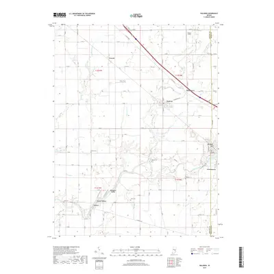
2019 Map of Waldron
USGS Topo · Published 2019About this map
St. Paul and Waldron anchor this part of Shelby County, where the landscape is defined by the winding course of the Flatrock River. The area maintains a high density of small rural burial grounds that offer significant value for genealogical research, including the Vienna Cem, Simmons Cem, and Means Cem. The settlement pattern follows a mix of traditional river-oriented clusters and the rigid grid of the Public Land Survey System, with small communities like Geneva and Middletown punctuating the agricultural fields. The transportation network is dominated by the diagonal corridor of E Michigan Rd, which cuts across the township lines. Unusual for such a rural area, the map features two distinct landing strips, Whelen Airport and Fischer Field, indicating the importance of light aviation to the local region. Several waterways, such as Conns Creek and Deer Cr, converge near the established town centers, illustrating the historical importance of drainage and water access in this part of Indiana.
Find a feature on this map
84 named features on this map. Tap any name to fly to it.
Don’t see what you’re looking for? This feature index may not catch every label — zoom into the map to look around manually.
Map Details
Editions of this 2019 Waldron Map
This is the sole edition of this map. No revisions or reprints were ever made.
Other maps of this area

1942 · Columbus
USGS Topo · 1:125,000

1947 · Hope
USGS Topo · 1:24,000

1948 · Hope
USGS Topo · 1:24,000

1948 · Lewis Creek
USGS Topo · 1:24,000

1950 · Edinburg
USGS Topo · 1:62,500

1953 · Shelbyville
USGS Topo · 1:24,000

1953 · Cincinnati
USGS Topo · 1:250,000

1956 · Waldron
USGS Topo · 1:24,000

1956 · Rays Crossing
USGS Topo · 1:24,000

1957 · Cincinnati
USGS Topo · 1:250,000