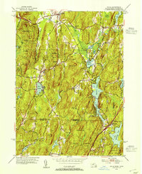
1952 Map of Wales
USGS Topo · Published 1954About this map
Brimfield State Forest and Nipmuck State Forest anchor this mid-century portrait of the Massachusetts and Connecticut borderlands. The landscape is defined by its significant water features, from the expansive Hamilton Reservoir and Holland Pond to smaller mountain waters like Lake George and Vinton Pond. Settlement patterns follow the winding valleys between high points such as Rattlesnake Mtn and Janes Hill, with established villages at Wales, Holland, and Brimfield connected by a network of rural roads like Monson Road and Reed Hill Road. Local institutional history is reflected in the presence of the Springfield Boys Camp and Springfield Girls Camp, while genealogical interests are served by the location of St Anns Cem and other rural burial grounds. The state line divides the northern town centers from the more secluded waters of Mashapaug Pond to the south.
Find a feature on this map
55 named features on this map. Tap any name to fly to it.
Don’t see what you’re looking for? This feature index may not catch every label — zoom into the map to look around manually.
Map Details
Editions of this 1952 Wales Map
4 editions found
Other maps of this area

1887 · Brookfield
USGS Topo · 1:62,500

1887 · Palmer
USGS Topo · 1:62,500

1889 · Palmer
USGS Topo · 1:62,500

1890 · Brookfield
USGS Topo · 1:62,500

1892 · Woodstock
USGS Topo · 1:62,500

1892 · Tolland
USGS Topo · 1:62,500

1893 · Palmer
USGS Topo · 1:62,500

1893 · Brookfield
USGS Topo · 1:62,500

1908 · Ware
USGS Topo · 1:125,000

1915 · Brookfield
USGS Topo · 1:62,500