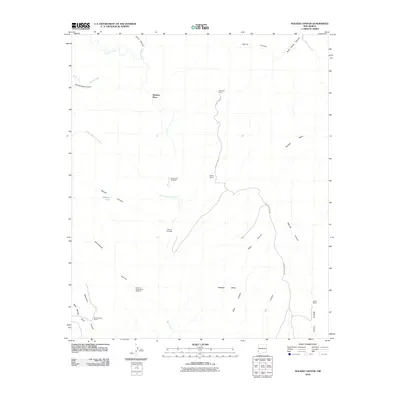
2010 Map of Walker Canyon
USGS Topo · Published 2010About this map
Matthew Place and a network of remote ranching outposts define this high-desert landscape in Grant County during the early 21st century. The map illustrates a reliance on specialized water infrastructure, noting essential points like Dutch John Windmill, Blakey Windmill, and Walker Tank that support livestock across the arid terrain. Rugged topography is carved by a dense system of drainages, including the prominent Walker Canyon, Cottonwood Canyon, and Elliot Canyon, which converge toward the broad Redrock Mesa. Human activity is primarily centered around named holdings such as Anderson Ranch, Blakey Ranch, and Mud Springs Ranch, all linked by the unpaved corridor of Brown Ranch Rd. This survey provides a clear look at how land use and water management persist in a region dominated by dramatic elevation changes and seasonal creek beds like Blue Creek and Little Sycamore Creek.
Find a feature on this map
28 named features on this map. Tap any name to fly to it.
Don’t see what you’re looking for? This feature index may not catch every label — zoom into the map to look around manually.
Map Details
Editions of this 2010 Walker Canyon Map
This is the sole edition of this map. No revisions or reprints were ever made.
Other maps of this area

1954 · Silver City
USGS Topo · 1:250,000

1958 · Silver City
USGS Topo · 1:250,000

1959 · Steeple Rock
USGS Topo · 1:62,500

1959 · Redrock
USGS Topo · 1:62,500

1959 · Canador Peak
USGS Topo · 1:62,500

1959 · Cliff
USGS Topo · 1:62,500

1962 · Silver City
USGS Topo · 1:250,000
1990 · Crookson Peak
USGS Topo · 1:24,000
1990 · Antelope Ridge
USGS Topo · 1:24,000
1990 · Walker Canyon
USGS Topo · 1:24,000