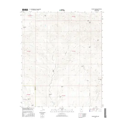
2017 Map of Walker Canyon
USGS Topo · Published 2017About this map
Walker Canyon and the surrounding drainage network of the Gila River watershed define this high-desert landscape on the border of Hidalgo and Grant Counties. The terrain is marked by a series of significant canyons, including Bud Wright Canyon and Cottonwood Canyon, which reveal a complex topographical relief rising toward High Lonesome Peak in the southeast. Water management for ranching is evident through features like Walker Tank and the seasonal flows of Blue Creek and Adams Creek. Remote access is provided by localized routes such as Brown Ranch Road and Mud Springs Ranch Road, which cross the wide expanse of Redrock Mesa. This 2017 survey details the intersection of rugged New Mexico geology and established grazing lands in the western reaches of the state.
Find a feature on this map
26 named features on this map. Tap any name to fly to it.
Don’t see what you’re looking for? This feature index may not catch every label — zoom into the map to look around manually.
Map Details
Editions of this 2017 Walker Canyon Map
This is the sole edition of this map. No revisions or reprints were ever made.
Other maps of this area

1954 · Silver City
USGS Topo · 1:250,000

1958 · Silver City
USGS Topo · 1:250,000

1959 · Steeple Rock
USGS Topo · 1:62,500

1959 · Redrock
USGS Topo · 1:62,500

1959 · Canador Peak
USGS Topo · 1:62,500

1959 · Cliff
USGS Topo · 1:62,500

1962 · Silver City
USGS Topo · 1:250,000
1990 · Crookson Peak
USGS Topo · 1:24,000
1990 · Antelope Ridge
USGS Topo · 1:24,000
1990 · Walker Canyon
USGS Topo · 1:24,000