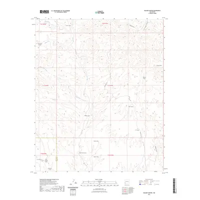
2023 Map of Walker Canyon
USGS Topo · Published 2023About this map
Walker Canyon and the high elevations of Redrock Mesa dominate this southwestern New Mexico landscape, where the border between Hidalgo and Grant counties cuts through the terrain. The drainage of Blue Creek serves as a primary north-south artery through the hills, collecting runoff from numerous side canyons including Little Sycamore Creek and Cottonwood Canyon. Human presence is defined by ranching infrastructure, most notably Walker Tank and the access provided by Brown Ranch Rd. The map reveals a topography of isolated basins and draws, such as Redrock Basin and Mud Springs Draw, reflecting the arid environment and seasonal water flow typical of this region's geomorphology.
Find a feature on this map
21 named features on this map. Tap any name to fly to it.
Don’t see what you’re looking for? This feature index may not catch every label — zoom into the map to look around manually.
Map Details
Editions of this 2023 Walker Canyon Map
This is the sole edition of this map. No revisions or reprints were ever made.
Other maps of this area

1954 · Silver City
USGS Topo · 1:250,000

1958 · Silver City
USGS Topo · 1:250,000

1959 · Steeple Rock
USGS Topo · 1:62,500

1959 · Redrock
USGS Topo · 1:62,500

1959 · Canador Peak
USGS Topo · 1:62,500

1959 · Cliff
USGS Topo · 1:62,500

1962 · Silver City
USGS Topo · 1:250,000
1990 · Crookson Peak
USGS Topo · 1:24,000
1990 · Antelope Ridge
USGS Topo · 1:24,000
1990 · Walker Canyon
USGS Topo · 1:24,000