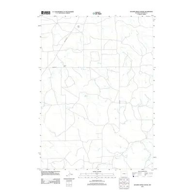
2012 Map of Walker Creek School
USGS Topo · Published 2012About this map
Herrick Reservoir sits at the heart of this rural landscape in Converse County, serving as a primary water source for the surrounding high plains ranching country. The drainage network is defined by several significant seasonal waterways, including Walker Cr, Piney Cr, and Cottonwood Cr, which carve shallow channels through the terrain. A series of draws, such as Well Draw and Gould Draw, illustrate the subtle topographic variations and natural drainage patterns of this eastern Wyoming region. Human presence is marked by a sparse network of county routes, including Walker Creek Rd and Dickau Rd, which connect remote properties and water points across the expansive rangeland. The map provides a detailed view of the water management and road systems necessary for agricultural life in this arid environment.
Find a feature on this map
12 named features on this map. Tap any name to fly to it.
Don’t see what you’re looking for? This feature index may not catch every label — zoom into the map to look around manually.
Map Details
Editions of this 2012 Walker Creek School Map
This is the sole edition of this map. No revisions or reprints were ever made.
Other maps of this area

1954 · Torrington
USGS Topo · 1:250,000

1955 · Newcastle
USGS Topo · 1:250,000

1958 · Torrington
USGS Topo · 1:250,000

1958 · Newcastle
USGS Topo · 1:250,000

1970 · Lost Springs
USGS Topo · 1:24,000
1970 · The Park
USGS Topo · 1:24,000

1970 · Bill 4 SE
USGS Topo · 1:24,000

1970 · Walker Creek School
USGS Topo · 1:24,000
1970 · Simpson Draw
USGS Topo · 1:24,000

1970 · Lost Springs NW
USGS Topo · 1:24,000