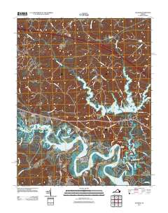
2011 Map of Walkers
USGS Topo · Published 2011About this map
Lanexa and the nearby settlement of Walkers sit at the heart of this landscape, where the tides of the Chickahominy River meet a complex network of landings and peninsulas. The area is defined by its water-dependent geography, featuring several historical access points such as Osborn Landing, Graves Landing, and the curiously named Fish Hole Landing. To the north and east, the large Diascund Creek Reservoir dominates the drainage basin, contrasted by the dense wetlands of Big Swamp and Tonyham Swamp. Notable land features include Matahunk Neck and Turner Neck, which reach into the river's winding course. This era shows a mix of rural residential development and conservation, with several named outposts and landings that suggest a long history of fishing and river commerce along this stretch of the Virginia Peninsula.
Find a feature on this map
62 named features on this map. Tap any name to fly to it.
Don’t see what you’re looking for? This feature index may not catch every label — zoom into the map to look around manually.
Map Details
Editions of this 2011 Walkers Map
This is the sole edition of this map. No revisions or reprints were ever made.
Other maps of this area

1917 · Toano
USGS Topo · 1:62,500

1918 · Charles City
USGS Topo · 1:62,500

1918 · Toano
USGS Topo · 1:62,500

1919 · New Kent
USGS Topo · 1:62,500

1920 · King William
USGS Topo · 1:62,500

1943 · Richmond
USGS Topo · 1:250,000

1949 · Tunstall
USGS Topo · 1:24,000

1949 · New Kent
USGS Topo · 1:24,000

1949 · Richmond
USGS Topo · 1:250,000

1950 · West Point
USGS Topo · 1:24,000