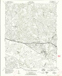
1953 Map of Walkers
USGS Topo · Published 1957About this map
The Chickahominy River defines the southern portion of this mid-century survey, its wide marshy reaches marked by Binns Bar and Matahunk Neck. In the early 1950s, the rural life of this Tidewater region centered on a series of small, rail-side communities like Walkers and Windsor Shades (Boulevard PO), where the Chesapeake and Ohio railroad line parallels the Pocahontas Trail. The map documents a spiritual and civic landscape through numerous rural institutions, including Tsena Commoko Ch, Ebenezer Ch, and the Lanexa Sch.
Find a feature on this map
44 named features on this map. Tap any name to fly to it.
Don’t see what you’re looking for? This feature index may not catch every label — zoom into the map to look around manually.
Map Details
Editions of this 1953 Walkers Map
This is the sole edition of this map. No revisions or reprints were ever made.
Other maps of this area

1917 · Toano
USGS Topo · 1:62,500

1918 · Charles City
USGS Topo · 1:62,500

1918 · Toano
USGS Topo · 1:62,500

1919 · New Kent
USGS Topo · 1:62,500

1920 · King William
USGS Topo · 1:62,500

1943 · Richmond
USGS Topo · 1:250,000

1949 · Tunstall
USGS Topo · 1:24,000

1949 · New Kent
USGS Topo · 1:24,000

1949 · Richmond
USGS Topo · 1:250,000

1950 · West Point
USGS Topo · 1:24,000