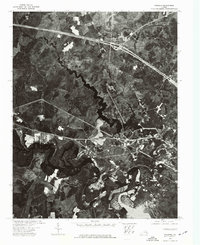
1973 Map of Walkers
USGS Topo · Published 1977About this map
Walkers sits at the center of this 1973 orthophotoquad, a hybrid document combining precise topographic control with actual aerial photography. This perspective reveals the intricate drainage patterns of the Chickahominy River system as it winds through New Kent County. The dark, sprawling waters of the Diascund Creek Reservoir dominate the eastern portion of the landscape, illustrating the mid-century transformation of Virginia's natural watercourses for regional utility. Unlike traditional line maps, this photographic view allows for the study of specific woodlots, field boundaries, and small-scale infrastructure as they existed during the early 1970s, providing a clear record of land use before subsequent decades of suburban development.
Find a feature on this map
4 named features on this map. Tap any name to fly to it.
Don’t see what you’re looking for? This feature index may not catch every label — zoom into the map to look around manually.
Map Details
Editions of this 1973 Walkers Map
This is the sole edition of this map. No revisions or reprints were ever made.
Other maps of this area

1917 · Toano
USGS Topo · 1:62,500

1918 · Charles City
USGS Topo · 1:62,500

1918 · Toano
USGS Topo · 1:62,500

1919 · New Kent
USGS Topo · 1:62,500

1920 · King William
USGS Topo · 1:62,500

1943 · Richmond
USGS Topo · 1:250,000

1949 · Tunstall
USGS Topo · 1:24,000

1949 · New Kent
USGS Topo · 1:24,000

1949 · Richmond
USGS Topo · 1:250,000

1950 · West Point
USGS Topo · 1:24,000