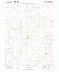
1979 Map of Walks Camp Park
USGS Topo · Published 1980About this map
Walks Camp Church and the nearby Walks Camp Cemetery anchor this eastern Colorado landscape, reflecting the community life of Lincoln County in the late 1970s. The terrain is defined by the winding course of the Arikaree River and its many tributaries, including the North Fork Arikaree River, Vega Creek, and Currie Creek. This area shows a functional mix of traditional land use and modern infrastructure, where a subterranean pipeline and a Gravel Pit coexist with local landmarks like the Thompson Landing Strips. The presence of several natural springs near Walks Camp Park highlights the vital role of water in this high plains environment, sustaining the small-scale developments and agricultural patterns recorded during this 1970s survey.
Find a feature on this map
12 named features on this map. Tap any name to fly to it.
Don’t see what you’re looking for? This feature index may not catch every label — zoom into the map to look around manually.
Map Details
Editions of this 1979 Walks Camp Park Map
This is the sole edition of this map. No revisions or reprints were ever made.
Other maps of this area

1891 · Limon
USGS Topo · 1:125,000

1892 · Limon
USGS Topo · 1:125,000

1954 · Limon
USGS Topo · 1:250,000

1957 · Limon
USGS Topo · 1:250,000

1958 · Limon
USGS Topo · 1:250,000

1970 · Limon
USGS Topo · 1:24,000

1970 · T Draw
USGS Topo · 1:24,000

1973 · Last Chance SW
USGS Topo · 1:24,000

1973 · Lusto Springs
USGS Topo · 1:24,000

1973 · Lindon SW
USGS Topo · 1:24,000