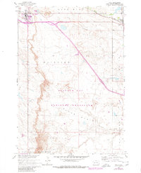
1960 Map of Wall
USGS Topo · Published 1980About this map
Wall and the smaller settlement of Quinn anchor this South Dakota landscape, situated along the corridor of the Chicago and North Western railroad. The topography is dominated by the dramatic shift from the plains of Buffalo Gap National Grassland into the northern reaches of the Badlands National Monument. This 1960 survey, updated with 1978 revisions, shows the area as it transitioned from a remote prairie junction into a regional waypoint, evidenced by the presence of a Landing Field and Trailer Park near the town center of Wall. The intricate drainage patterns of Cottonwood Creek and Whitewater Creek carve through landforms like Bloom Basin and Lake Hill, illustrating the erosive forces that characterize the edge of the Badlands. The map also documents the transition of several land parcels from the Fairview district toward the designated grassland and monument boundaries.
Find a feature on this map
19 named features on this map. Tap any name to fly to it.
Don’t see what you’re looking for? This feature index may not catch every label — zoom into the map to look around manually.
Map Details
Editions of this 1960 Wall Map
2 editions found
Other maps of this area

1953 · Rapid City
USGS Topo · 1:250,000

1954 · Wasta SE
USGS Topo · 1:24,000

1955 · Hot Springs
USGS Topo · 1:250,000

1957 · Rapid City
USGS Topo · 1:250,000

1960 · Quinn Table NE
USGS Topo · 1:24,000

1960 · Wall SE
USGS Topo · 1:24,000

1960 · Wall
USGS Topo · 1:24,000

1960 · Quinn Table SE
USGS Topo · 1:24,000
1960 · Wall SW
USGS Topo · 1:24,000
1961 · Wall NE
USGS Topo · 1:24,000