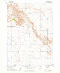
1960 Map of Wall SW
USGS Topo · Published 1962About this map
Badlands National Monument dominates this 1960 survey, revealing the striking topography of southwestern South Dakota before modern infrastructure reshaped the park's visitor access. The map details the sharp descent from the northern high ground at The Pinnacles down into the expansive Conata Basin. This transition is navigated via Dillon Pass, a critical geographic waypoint for travelers and early park rangers. The presence of Dillon Campground suggests the mid-century development of recreational facilities within the monument boundaries. To the east, the vertical relief is defined by the prominent Flat Butte and Castle Butte, while fine red dashed lines indicate fencelines and field boundaries that speak to the ranching history surrounding the federal lands in Pennington Co.
Find a feature on this map
10 named features on this map. Tap any name to fly to it.
Don’t see what you’re looking for? This feature index may not catch every label — zoom into the map to look around manually.
Map Details
Editions of this 1960 Wall SW Map
2 editions found
Other maps of this area

1950 · Conata
USGS Topo · 1:24,000

1950 · Bouquet Table
USGS Topo · 1:24,000

1952 · Conata NE
USGS Topo · 1:24,000

1952 · Bouquet Table
USGS Topo · 1:24,000

1952 · Conata
USGS Topo · 1:24,000

1955 · Hot Springs
USGS Topo · 1:250,000

1960 · Quinn Table NE
USGS Topo · 1:24,000

1960 · Wall SE
USGS Topo · 1:24,000

1960 · Wall
USGS Topo · 1:24,000

1960 · Quinn Table SE
USGS Topo · 1:24,000