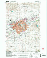
1998 Map of Walla Walla
USGS Topo · Published 2003About this map
The sprawling campus of Whitman College and the landmark State Penitentiary anchor the northern reaches of this detailed Washington study. In the late 20th century, Walla Walla appears as a dense grid of residential and institutional life, where historical legacies meet mid-century expansion in neighborhoods like Eastgate and the nearby city of College Place. The city’s southern fringe reveals a shift from urban blocks to an agricultural and hydraulic landscape, defined by the irrigation network of Yellowhawk Creek, Russell Creek, and Caldwell Creek.
Find a feature on this map
80 named features on this map. Tap any name to fly to it.
Don’t see what you’re looking for? This feature index may not catch every label — zoom into the map to look around manually.
Map Details
Editions of this 1998 Walla Walla Map
This is the sole edition of this map. No revisions or reprints were ever made.
Other maps of this area

1919 · Walla Walla
USGS Topo · 1:125,000

1921 · Walla Walla
USGS Topo · 1:125,000

1953 · Pendleton
USGS Topo · 1:250,000

1953 · Walla Walla
USGS Topo · 1:250,000

1956 · Pendleton
USGS Topo · 1:250,000

1958 · Walla Walla
USGS Topo · 1:250,000

1963 · Peterson Ridge
USGS Topo · 1:24,000

1964 · Milton-Freewater
USGS Topo · 1:24,000

1964 · Bowlus Hill
USGS Topo · 1:24,000

1966 · Dixie
USGS Topo · 1:24,000