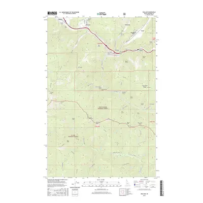
2017 Map of Wallace
USGS Topo · Published 2017About this map
The S Fork Coeur d'Alene River valley forms the industrial and residential spine of this northern Idaho landscape, where the communities of Wallace, Osburn, and Silverton are concentrated between high mountain ridges. This 2017 survey details the complex geography of the Silver Valley, from the urban streets of Bank ST and Mullan Ave to the isolated peaks of the St Joe Mountains. Local history is anchored by the Miners Union Cem and Nine Mile Cem near Woodland Park, reflecting the region's deep mining heritage. To the south, the terrain rises into the Coeur d'Alene National Forest and St. Joe National Forest, a wilderness defined by prominent landmarks like Placer Peak and the Coeur d'Alene Saint Joe Divide. The map traces numerous gulches and creeks, such as Shields Gulch and Placer Cr, that have long shaped the region's development and natural resource extraction.
Find a feature on this map
83 named features on this map. Tap any name to fly to it.
Don’t see what you’re looking for? This feature index may not catch every label — zoom into the map to look around manually.
Map Details
Editions of this 2017 Wallace Map
This is the sole edition of this map. No revisions or reprints were ever made.
Other maps of this area

1901 · Coeur D'Alene District
USGS Topo · 1:62,500

1903 · Coeur D'Alene District
USGS Topo · 1:62,500

1906 · Coeur D'Alene District
USGS Topo · 1:62,500

1909 · Cataldo
USGS Topo · 1:125,000

1911 · Cataldo
USGS Topo · 1:125,000

1914 · Avery
USGS Topo · 1:125,000

1917 · Avery
USGS Topo · 1:125,000

1932 · Trout Creek
USGS Topo · 1:125,000

1935 · Trout Creek
USGS Topo · 1:125,000

1936 · Trout Creek
USGS Topo · 1:125,000