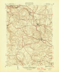
1946 Map of Wallaceton
USGS Topo · Published 1946About this map
Wallaceton sits at the heart of this post-war survey, surrounded by a dense network of small coal-era settlements and rural community hubs. The landscape is defined by the three townships of Boggs, Decatur, and Morris, where the distribution of one-room schools like the Eagle Eye Sch and Ohio Sch reflects a dispersed population in the mid-1940s. Transportation is anchored by the Moravian railroad line and a series of winding runs including Roaring Run and Little Laurel Run, which carved the narrow valleys that dictated early road and rail placement.
Find a feature on this map
39 named features on this map. Tap any name to fly to it.
Don’t see what you’re looking for? This feature index may not catch every label — zoom into the map to look around manually.
Map Details
Editions of this 1946 Wallaceton Map
2 editions found
Other maps of this area

1903 · Houtzdale
USGS Topo · 1:62,500

1905 · Houtzdale
USGS Topo · 1:62,500

1922 · Philipsburg
USGS Topo · 1:62,500

1929 · Karthaus
USGS Topo · 1:62,500

1929 · Clearfield
USGS Topo · 1:48,000

1932 · Clearfield
USGS Topo · 1:62,500

1932 · Karthaus
USGS Topo · 1:62,500

1939 · Philipsburg
USGS Topo · 1:62,500

1944 · Houtzdale
USGS Topo · 1:24,000
1944 · Glen Richey
USGS Topo · 1:24,000
Featured Places
- Bigler, Bradford Township
- Wallaceton, PA
- Decatur Township, PA
- Spring Valley, Boggs Township
- Morris Township, PA