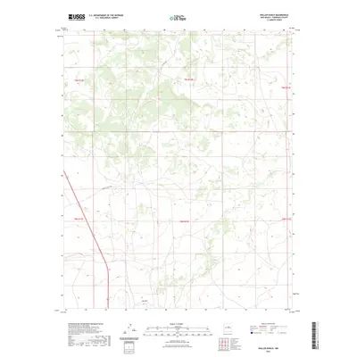
2023 Map of Waller Ranch
USGS Topo · Published 2023About this map
Red Hill marks a point of interest in this high-altitude landscape of Torrance County, where the topography is defined by the transitions between the T8N and T9N townships. The area is characterized by its rural ranching infrastructure, primarily centered around Waller Ranch Rd and Co Rd C106, which provide access through the undulating terrain. Highway 285 cuts through the southwestern corner of the quadrangle, serving as the primary transportation artery connecting this remote section of New Mexico to the broader region. This 2023 survey by the U.S. Geological Survey illustrates the contemporary land management boundaries and the sparse but vital road network that supports the local ranching economy.
Find a feature on this map
10 named features on this map. Tap any name to fly to it.
Don’t see what you’re looking for? This feature index may not catch every label — zoom into the map to look around manually.
Map Details
Editions of this 2023 Waller Ranch Map
This is the sole edition of this map. No revisions or reprints were ever made.
Other maps of this area

1890 · Bernal
USGS Topo · 1:125,000

1891 · Bernal
USGS Topo · 1:125,000

1894 · Bernal
USGS Topo · 1:125,000

1894 · Lamy
USGS Topo · 1:125,000

1954 · Santa Fe
USGS Topo · 1:250,000

1954 · Fort Sumner
USGS Topo · 1:250,000

1958 · Fort Sumner
USGS Topo · 1:250,000

1958 · Santa Fe
USGS Topo · 1:250,000

1963 · Jacinto Mesa
USGS Topo · 1:24,000
1966 · El Cabo
USGS Topo · 1:24,000