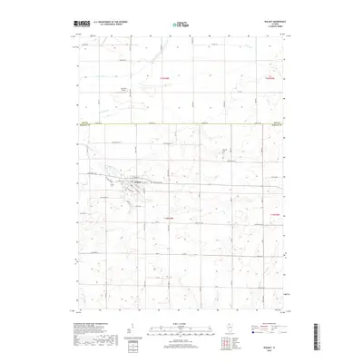
2018 Map of Walnut
USGS Topo · Published 2018About this map
Walnut serves as the primary hub of this landscape on the border of Bureau and Lee counties. The town's grid is anchored by E North St, E Walnut St, and Depot St, reflecting a historic reliance on the local transit network. Agricultural drainage is a defining characteristic of the surrounding terrain, with the Green River and several engineered waterways like Red Oak Ditch and Normandy Ditch managing the prairie's water levels. For those researching local lineages, the Walnut Cem and Red Oak Cem are key landmarks. Further north, the Fisch RLA Airport sits near the Green River, while the southern reaches are marked by the winding path of W Bureau Cr.
Find a feature on this map
61 named features on this map. Tap any name to fly to it.
Don’t see what you’re looking for? This feature index may not catch every label — zoom into the map to look around manually.
Map Details
Editions of this 2018 Walnut Map
This is the sole edition of this map. No revisions or reprints were ever made.
Other maps of this area

1893 · Hennepin
USGS Topo · 1:62,500

1909 · Hennepin
USGS Topo · 1:62,500

1911 · Hennepin
USGS Topo · 1:62,500

1921 · Buda
USGS Topo · 1:62,500

1923 · Buda
USGS Topo · 1:62,500

1949 · Walnut
USGS Topo · 1:62,500

1951 · Amboy
USGS Topo · 1:62,500

1958 · Aurora
USGS Topo · 1:250,000

1961 · Aurora
USGS Topo · 1:250,000
1966 · Princeton North
USGS Topo · 1:24,000