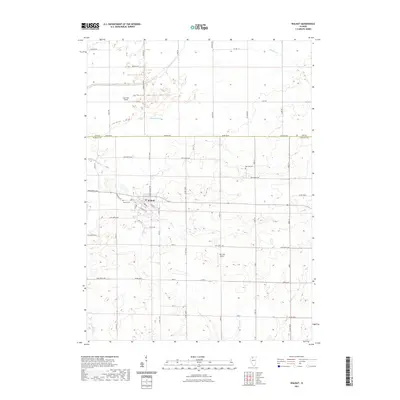
2021 Map of Walnut
USGS Topo · Published 2021About this map
The agricultural landscape of Bureau County is anchored by the village of Walnut, situated at the intersection of Wyanet Walnut Rd and local thoroughfares like Ross St and E Walnut St. This 2021 survey illustrates a region where managed drainage is critical to the local economy, evidenced by the extensive network of the Green River, Red Oak Ditch, and Normandy Ditch. The presence of private aviation facilities, including Fisch RLA Airport and Wilt RLA Airport, underscores the scale of modern farming operations and the dispersed nature of local transportation. Genealogists will find the locations of Walnut Cem and Red Oak Cem preserved on the map. To the north, the boundary between Lee Co and Bureau Co runs along Baseline Rd, marking the division of these fertile Illinois prairie lands.
Find a feature on this map
59 named features on this map. Tap any name to fly to it.
Don’t see what you’re looking for? This feature index may not catch every label — zoom into the map to look around manually.
Map Details
Editions of this 2021 Walnut Map
This is the sole edition of this map. No revisions or reprints were ever made.
Other maps of this area

1893 · Hennepin
USGS Topo · 1:62,500

1909 · Hennepin
USGS Topo · 1:62,500

1911 · Hennepin
USGS Topo · 1:62,500

1921 · Buda
USGS Topo · 1:62,500

1923 · Buda
USGS Topo · 1:62,500

1949 · Walnut
USGS Topo · 1:62,500

1951 · Amboy
USGS Topo · 1:62,500

1958 · Aurora
USGS Topo · 1:250,000

1961 · Aurora
USGS Topo · 1:250,000
1966 · Princeton North
USGS Topo · 1:24,000