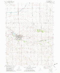
1982 Map of Walnut
USGS Topo · Published 1982About this map
Walnut serves as the primary hub of this northern Illinois prairie landscape, where the Burlington Northern railroad bisects the town and parallels the winding course of Walnut Creek. The map records a fascinating historical layer in the Old Indian Treaty Boundary, which cuts a straight diagonal across the southern section of the quadrangle, marking an earlier era of land division. To the north, the Green River flows through the township of Hamilton, bordered by rural routes like Keigwin Br Road and Burke Road. The cultural landscape is anchored by the Red Oak Ch and Red Oak Cem, located near the Green River Golf Course. Small industrial footprints such as a Gravel Pit and a southern Quarry appear alongside local transit markers like the Joder Landing Strip, reflecting a mix of agriculture and light industry.
Find a feature on this map
27 named features on this map. Tap any name to fly to it.
Don’t see what you’re looking for? This feature index may not catch every label — zoom into the map to look around manually.
Map Details
Editions of this 1982 Walnut Map
This is the sole edition of this map. No revisions or reprints were ever made.
Other maps of this area

1893 · Hennepin
USGS Topo · 1:62,500

1909 · Hennepin
USGS Topo · 1:62,500

1911 · Hennepin
USGS Topo · 1:62,500

1921 · Buda
USGS Topo · 1:62,500

1923 · Buda
USGS Topo · 1:62,500

1949 · Walnut
USGS Topo · 1:62,500

1951 · Amboy
USGS Topo · 1:62,500

1958 · Aurora
USGS Topo · 1:250,000

1961 · Aurora
USGS Topo · 1:250,000
1966 · Princeton North
USGS Topo · 1:24,000